Svydovetskyi khrebet - Rakhiv
Svydovetskyi khrebet: how do i get there and where it is placed, how it works (what time it opens and when it closes), address, phone number, entrance ticket price, official website, reviews of employees and tourists, photos and videos, description of the attraction, routes, location on the map
View:
Address:
Description of the sight
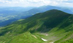
The Svidovets ridge, or Svidovets, is located in the southeastern part of the Ukrainian Carpathians, between the Teresva and Chernaya Tisza rivers, near the village of Yasinya, in the northeast of the Transcarpathian region. The entire length of the ridge is 1500 meters high. Svidovets is a common name for three ranges: Svidovets, Apshinets and Urdu-Flavantuch. From the west it surrounds the geographical center of Europe. The highest point of the ridge is Mount Bliznitsa, whose height is 1883 meters. The steep northern slopes of Svidovets are covered with spruce forests, and the gentle southern slopes are covered with beech and spruce-beech forests, there are also wide valleys. On the cliffs of Svidovets you can find a rare kind of flower - Alpine edelweiss. The Black Tisza River, the source of the most full-flowing Carpathian Tisza River, originates on Svidovets. There are seven alpine lakes on the ridge, thanks to which Svidovets is called the Sea Eye. Of these, one can single out such lakes as Dragobratskoye, Apshinets, Vorozheska and Hereshaska. On the spurs of Svidovets there is a ski resort Dragobrat, the highest in Ukraine. It is known for the fact that the snow cover here lasts 6 months a year.